No, honestly, it wasn’t that bad. I was just inspired by the title of the premier for one of the Doctor Who seasons I was watching in the States before “geographical restrictions” cut me off. As a note on that, Amazon doesn’t seem to have a lot of content down here that we had been watching. But, Netflix does (even if they didn’t have it in the States). That said, we might have considered keeping our Netflix subscription, except that it doesn’t support downloading movies onto our tablet (Nexus 10, since it isn’t a commonly used device).
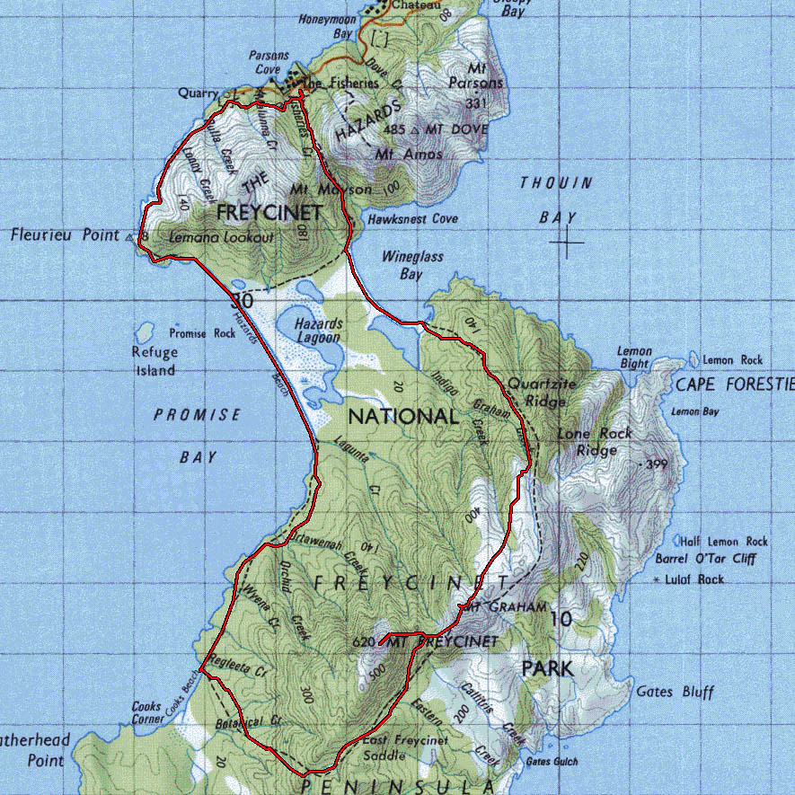
Anyway, back to the title. We had just finished the 2 “strenuous” day hikes at St Patrick’s Head and Douglas-Apsley National Park and were taking a rest day as we camped in Freycinet National Park. If you have ever heard of Tasmania, in other terms than of the Tasmanian Devil cartoon, you may have heard of Wineglass Bay. This beautiful highly-photographed beach is located here in this park. Rather than just being attracted to that site, though; Jonathan had heard that the Peninsula Circuit (a 3 day hike) is great. Offering far better views than those who just wander to the Wineglass Bay lookout. He seemed confident that we could do it, but I had my trepidations. We had only walked at most 5km (by the way, in my head, I normally say “ks” or “clicks” every time I see km, since saying kilometer is so long) in a day. I think most hikes we had done were closer to 3-4 (though often steeper) and we had always taken much longer than the posted signage for the journeys. This 3-day hike consisted of a 12km day 1, a 15km day 2, and a 5km day 3. To top it off, the long day 2 was steep, going up between 2 small granite “mountains.” Comparing past walks to the future walk, it just didn’t add up well.
However, I read up on the hike on a blog. They made it sound easy. So, convinced, we started planning the trip while we did some laundry. First, we drove around looking for an outdoor store that would have freeze-dried foods, but didn’t have any success, so we made a trip to the grocery store to see if we could pick up some items we knew would work on the trail. Then while waiting on the laundry cycle to end, we took inventory of the food and Jonathan did some math to figure out if he would have enough calories for the trip. He was determined to not starve. We finally figured out enough food and meals for 3 days. The laundry finished and we went to find a camping site. Since we didn’t want to have a long drive in the morning, we tried to find a spot close to the trailhead carpark. There were none available (it was a Saturday), so we settled in the carpark, which is apparently a $318 fine, as we found out in the morning (thankfully only warned about, not issued, but I don’t recommend trying that). I set about cooking dinner (an ambitious Curry Vegetable Pot Pie, where I even made my own biscuits since Australia doesn’t seem to have any refrigerated “scone” dough here). Jonathan was taking a break watching a show. We let time get away from us, and so we did not get a chance to pack up everything like we had planned and left it all for the morning.
Sunday morning, we started pulling out our gear and figuring out what we wanted to take. After some trial and error, we eventually got some manageable-sized packs situated. We estimate that weighed about the same somehow (not ideal, since I weigh about 35 pounds less than him) at about 30-35 pounds, carrying 6 liters of water. The water was the killer part. We learned that there was only water, which was limited, at one of the campgrounds, so we needed to carry enough for 1.5 days, including drinking and cooking. We estimated 3 liters per person per day. We ended up using only 1 liter per person per day, then about 0.5-1 liter for cooking per day. We started out around 1015, then realized we had forgotten the sandwiches we had planned for lunch that day. Since we hadn’t gone far, we went back and made them and added them to the pile.
Finally, at 1030, we were officially on our way. But, by the time we got to the fork for our trail, we realized that we hadn’t seen the trail register. You are supposed to check in and out so that they know if you are lost and how long you have been gone, etc. I suspect they also use it to figure out if the vehicles in the parking lot are being camped in or just parked overnight. So, I watched Jonathan’s pack while he went back to find it. All boxes checked, we finally were on the trail. Only 2kms in though, we already needed to stop for lunch. As a plus, each time we stop for a meal or take a drink, our packs get a bit lighter!


We were both doing fairly well, though a bit tired, over the first 6km (which I thought was a really long 4km the first time down it). However, my right foot’s arch was feeling a bit cramped, so I removed my inserts and retied my shoes. At this point, we hit Hazards Beach. It was at low tide (ish). Most of the coarser granite sand couldn’t support our weight. After some trial and error, we found some sand that didn’t sink in while walking on it. By the time we reached the first campsite (Hazards Camp) at the end of the beach, I was exhausted, my arch still hurt, and both feet were really feeling it. After taking a restroom break, I got a foot massage and Jonathan got a shoulder massage for our sorest parts, and we moved on. Only 4 more kms to go, approximately 1.5 hours, which was closer 2.25 hours for us. But, we finally made it, footsore and exhausted. Upon pulling off my shoes, I realized I had a large blister on my left heel as well.
We set up camp, but while making dinner, we discovered we had chosen a poor spot. The wind kept blowing up this fine black sand and grit into our tent. We were covered in it. So, we decided to relocate. At this point, I could barely walk at all. Not very promising for the hike ahead. However, we both took some time to stretch and walked down to Cooks Beach to get some salt-water therapy. Walking in the cold water did help my feet a bit, as it constricted the blood vessels, reducing inflammation and pain. Jonathan actually rinsed off in the frigid water. As a plus, it was a beautiful sunset. However, our hot-weather gear was just not sufficient for the 50°F temperatures and breezes that night, so we were both a bit cold. And, we had forgotten our ear plugs. And, the sleeping pads we had are not anywhere near as comfy as our own bed. Made it a bit miserable and neither of us got much sleep.


After a walk to the bathroom in the morning, we made the decision that it was just too painful to continue on and do a longer, more strenuous hike. I thought this had been made for both of us, but later on I discovered that Jonathan thought he could have done it without me; nothing like thinking that I am holding someone back from a great experience! We held out hope that we were going to circle through Wineglass Bay on the way back, since it was a similar distance. But, as we got closer to the turnoff, I realized I would not be able to handle the elevation changes on the last bit of the hike. Probably a wise choice that we did avoid it, because by the end of the milder hike, I could barely walk. During the last 6 kms, we were both feeling every step of the journey. Every foot pounding through our bodies. Jonathan ended up carrying my pack through the parking lot. For the last 2 kms, I had tried to pick up my pace like a horse heading back to the barn, but I was in too much pain to do so. We had left at 845 that morning and got to the parking at about 4pm, which was only 45 minutes earlier than we had arrived the day before in the reverse direction. What should have been a 5-hour hike (according to everyone else) had been a 7.25 hour hike because of the pain.


You can tell we weren’t thinking quite well because of lack of sleep and hurry. There were several other options we could have done than the rigorous path we choose. For example, we could have stayed another night at Cooks camp to recover. Or we could have not gone 12kms the first day and instead, done 8. Then used the isthmus track to go to Wineglass Bay camp. Then we could have left our packs at the camp and done a round-trip day hike to Mount Freycinet. Alas, instead, we punished ourselves. You would think we are masochists, but we definitely did NOT enjoy it.
While relaxing in the carpark before trying to find a campsite for the night, we ran into our new friends and spent the evening hanging out with them. Between the friends and the great views, it wasn’t a total loss for the day.
They were heading down the same path the next day, planning to do the whole circuit, so we made plans to take 2 rest days and catch up with them at Wineglass Bay Campground so that we wouldn’t miss out on the iconic experience.


The second try at a walk in the park was much more successful. Only planning on one night stay, the water and food requirements were much less, making our bags lighter. We also remembered our ear plugs. And, the walk was only 5 kms per day.


