Tuesday, March 14, 2017

Tasmania’s South


After Our visit to the Tasman Peninsula we drove to Hobart for supplies/laundry/internet.  While In Hobart we visited the Museum of Old and New Art (MONA).  MONA is a world class museum with everything from classical paintings and early Japanese Art to modern pieces by contemporary Australian artists. Definitely worth a visit, just plan on taking half a day to explore it fully. 
The directors parking spot should give you a rough idea of their management philosophy. They both drove Tesla electric cars.
DSCN1108

After a brief visit to Hobart we drove back to the east coast to ferry to Bruny Island.  
DSCN1113
DSCN1154
DSCN1141
DSCN1146
DSCN1149
DSCN1160
Here is some ruins of an abandoned logging camp.  This was the winch used to pull huge trunks up the hill side for rough milling.  The steam pistons made 14 horsepower!  All the trees you see around the equipment have grown in the 40 years since the camp was closed.  This mountain was logged for almost 100 years, the majority of its timber was used in boat constructions.
DSCN1166
Here is the boiler. 
DSCN1165
DSCN1164
After we returned from bruny we visited a local in the Huon valley.  While we enjoyed the view from his balcony and uploaded photos, we also got to watch several wooden sailing vessels in the river.  Very relaxing, I can see why people move here from the mainland.


We continued south from the Huon valley to the southern coast. At the end of the road (literally), we left the van, and continued  on foot.  This is the southernmost point in Australia.

DSCN1169
DSCN1170
From there we trekked south through the bush to the cape.
DSCN1177
DSCN1179
About 2,000 miles that way lies Antarctica.  The surf was intense, as the waves born in the gales of the roaring 40s crashed against the beach.  Often there were 6 or more rows of rolling breakers coming in simultaneously.  
DSCN1180
DSCN1186
Some track workers has just finished replacing the long stair that lead to the campground here.  Being so remote means that most track work in Australia is done with helicopters.  Workers are airlifted in as well as materials.  They live on the track until the work is done, then they are flown out.
DSCN1190
DSCN1193
DSCN1200
DSCN1196

Most of Tasmania’s southwest is a vast wilderness area accessible only by foot or air. The  South Cape Bay you saw above is the endpoint of the southern coast track.  Most people walking this 7 day track are flown into the start point, and walk their way out.

Tuesday, March 7, 2017

Another Attempt at an Extended Hike

By Jen.

After Freycinet, we decided to hit up Maria Island. But, we decided that we must update our camping supplies before we did that. Last retirement in North America, we felt like we missed out on some really awesome sights because we didn’t have camping gear to go on overnight hikes. So, this time around, we made sure to have some basics. We received a lot on loan from a generous friend at work, but I was still missing a sleeping bag and we didn’t have a camp dining set. Plus, the sleeping pad I picked up from Amazon on a lightning Black Friday deal was terrible. Since Tasmania seems to have an abundance of these hikes, instead of heading directly to Maria Island, we headed towards Hobart to find an outdoor store. After visiting several shops to find exactly what we wanted, we were mostly set, and made our way back to Triabunna to catch the (person) ferry to Maria Island. However, the ferry people hadn’t responded to my email yet and so I tried calling them. To save money, I tried calling on wifi, but the connection wasn’t good enough. Irritated, I called by the cellular network, and was told to call back because they were on the line with someone else. After several minutes, I called back and was told to hold again, so I hung up. As you can imagine, by this point I was annoyed and stressed. At the next time, I called, she took my call, but told me the ferry was booked for the next day and I wouldn’t be able to get on until the day after next. With this delay and since arranging the trip to Maria Island was stressing me out, we decided to skip it and instead head to the Tasman Peninsula.
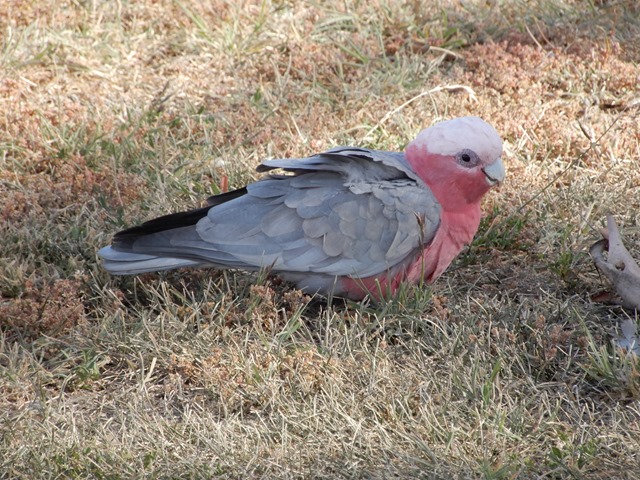
cute birds

These cute birds were swarming the campground we were at in Richmond. So cute! It is a Pink Galah.

DSCN0848

Oldest historic working bridge in Australia. Located in Richmond.

In the Tasman National Park, there is another multi-day hike to Cape Pillar, which is supposed to be really good. The most known route is a really cool Three Capes Experience walk that visits all 3 capes on the peninsula and includes a small ocean cruise, pickup from finish, and you get to stay in nice rooms every night. But, since we are cheapwads, we wanted to hike it for free. There is an option to do so. In theory, if you are really fit, you can do a 28km day trip, but I knew that was out of the question for me. The alternative is to use the Wughalee Falls campground and turn it into a 2 or 3 day overnight trip. We chose to make it a 3-day trip and do a circuit, returning by Cape Hauy. We hoped this time we could actually do the whole trip without turning back and not finishing. Fortunately, this 3-day hike is set up a bit more manageably, as your first day is only 7-8km with a pack. Then you can leave your pack with your tent at the camp, and make the trip to Cape Pillar (map says 14km, someone’s GPS showed 20km) without a pack and only light provisions. However, the last leg is a bit harder. We forgot to record the map and thought the last leg was a bit shorter, but it turns out that it is 17km (with a pack).

DSCN0862

Fortescue Bay Beach.

It started off pretty well, but then I realized I had forgotten to tape my knee before we left. Not good, but nothing I could do about it until we camped that night. We arrived early in the day at the camp, feeling well, except for my knee, which was killing me, especially because the last 850m had been a torturous and slippery downhill (the steepest part of the whole walk). Downhills are especially hard on my knee, and without the tape, I was really struggling. We rested the rest of the day and met a nice couple that we talked to for a couple of hours. The next day, we successfully made it all the way to cape without too much pain or problems. But on the way back, the distance started wearing on me, especially on my feet this time. But, we made it back to camp with no problem. On the last leg, Jonathan wanted to return the way we came with a short 8km walk, but I (with my what’s-around-the-next-corner attitude) wanted to take the long way back and hit up Cape Hauy, as I didn’t think we would get around to it otherwise. As I mentioned though, we weren’t sure how long it was. After checking our internet history, all we knew was that it was less than 17km. We figured we go to the Three Capes hut and ask the ranger there about the track. But, when we arrived, the ranger had already left. Figuring that the cushy Three-Capes walkers could handle the walk, we decided to press on. However, it was a bit steeper than we expected, and longer. We did make it, but we decided to skip the spur that actually lead to the edge of the cape. I am calling it mostly a success!
DSCN0865

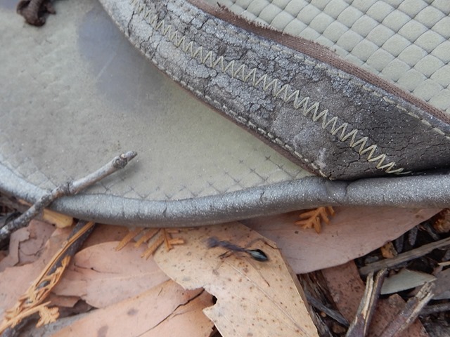
They have huge ants here!

DSCN0911

Tasman Island off of Cape Pillar’s Blade.

DSCN0918

Seal Colony off of Tasman Island.

DSCN0938


PANO_20170223_112938

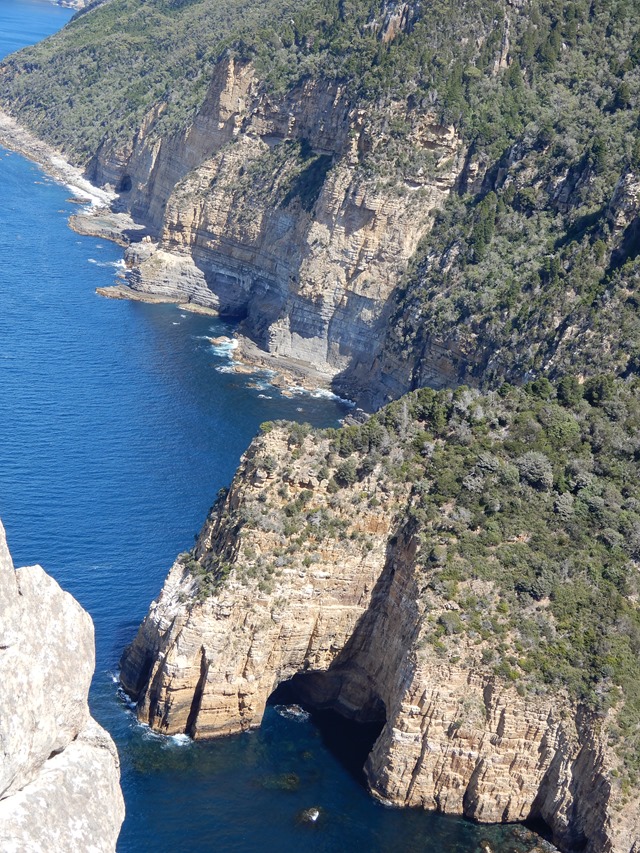
This cape has the tallest sea cliffs in the Southern Hemisphere. These are made of dolomite rock.
DSCN0988

DSCN0998

Next day, to “rest” before we left the campground, I wanted to go out on the kayak in the bay. It turned out to be a bit longer of kayak than I planned as well. In fact, I think we are accidentally developing an active lifestyle. We did about 40 km of walking/hiking in 3 days followed by 7kms of kayaking the next day. We still aren’t up to the level of most bushwalking Australians, though. Did we mention bushwalking (basically hiking) is a national pastime here, and they take it seriously. All their signs are posted for a brisk pace without stopping. We typically have to add an hour to any of the posted estimates. Anyways, after kayaking we made our way out of the peninsula, but not before stopping at the “unzoo” to see some Tasmanian devils!

DSCN1037

Sunk for fish.

DSCN1052

DSCN1096

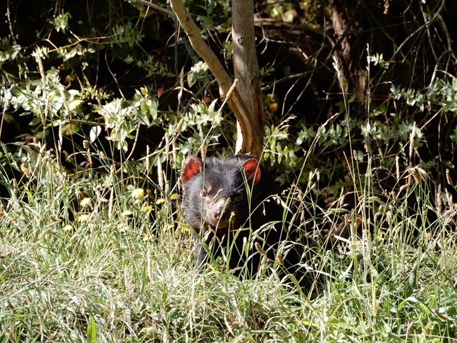
Tasmanian Devils. Apparently they are totally just scavengers, but eat the entire carcass, bone and everything!

DSCN1073


DSCN1085

Joey action with some Forester Kangaroos at the Unzoo.

Saturday, February 18, 2017

“Voyage of the Damned”

By Jen.
No, honestly, it wasn’t that bad. I was just inspired by the title of the premier for one of the Doctor Who seasons I was watching in the States before “geographical restrictions” cut me off. As a note on that, Amazon doesn’t seem to have a lot of content down here that we had been watching. But, Netflix does (even if they didn’t have it in the States). That said, we might have considered keeping our Netflix subscription, except that it doesn’t support downloading movies onto our tablet (Nexus 10, since it isn’t a commonly used device).
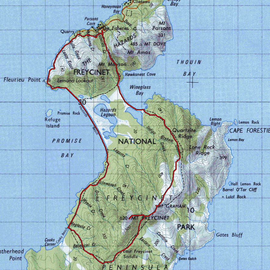
Anyway, back to the title. We had just finished the 2 “strenuous” day hikes at St Patrick’s Head and Douglas-Apsley National Park and were taking a rest day as we camped in Freycinet National Park. If you have ever heard of Tasmania, in other terms than of the Tasmanian Devil cartoon, you may have heard of Wineglass Bay. This beautiful highly-photographed beach is located here in this park. Rather than just being attracted to that site, though; Jonathan had heard that the Peninsula Circuit (a 3 day hike) is great. Offering far better views than those who just wander to the Wineglass Bay lookout. He seemed confident that we could do it, but I had my trepidations. We had only walked at most 5km (by the way, in my head, I normally say “ks” or “clicks” every time I see km, since saying kilometer is so long) in a day. I think most hikes we had done were closer to 3-4 (though often steeper) and we had always taken much longer than the posted signage for the journeys. This 3-day hike consisted of a 12km day 1, a 15km day 2, and a 5km day 3. To top it off, the long day 2 was steep, going up between 2 small granite “mountains.” Comparing past walks to the future walk, it just didn’t add up well.

However, I read up on the hike on a blog. They made it sound easy. So, convinced, we started planning the trip while we did some laundry. First, we drove around looking for an outdoor store that would have freeze-dried foods, but didn’t have any success, so we made a trip to the grocery store to see if we could pick up some items we knew would work on the trail. Then while waiting on the laundry cycle to end, we took inventory of the food and Jonathan did some math to figure out if he would have enough calories for the trip. He was determined to not starve. We finally figured out enough food and meals for 3 days. The laundry finished and we went to find a camping site. Since we didn’t want to have a long drive in the morning, we tried to find a spot close to the trailhead carpark. There were none available (it was a Saturday), so we settled in the carpark, which is apparently a $318 fine, as we found out in the morning (thankfully only warned about, not issued, but I don’t recommend trying that). I set about cooking dinner (an ambitious Curry Vegetable Pot Pie, where I even made my own biscuits since Australia doesn’t seem to have any refrigerated “scone” dough here). Jonathan was taking a break watching a show. We let time get away from us, and so we did not get a chance to pack up everything like we had planned and left it all for the morning.
Sunday morning, we started pulling out our gear and figuring out what we wanted to take. After some trial and error, we eventually got some manageable-sized packs situated. We estimate that weighed about the same somehow (not ideal, since I weigh about 35 pounds less than him) at about 30-35 pounds, carrying 6 liters of water. The water was the killer part. We learned that there was only water, which was limited, at one of the campgrounds, so we needed to carry enough for 1.5 days, including drinking and cooking. We estimated 3 liters per person per day. We ended up using only 1 liter per person per day, then about 0.5-1 liter for cooking per day. We started out around 1015, then realized we had forgotten the sandwiches we had planned for lunch that day. Since we hadn’t gone far, we went back and made them and added them to the pile.
Finally, at 1030, we were officially on our way. But, by the time we got to the fork for our trail, we realized that we hadn’t seen the trail register. You are supposed to check in and out so that they know if you are lost and how long you have been gone, etc. I suspect they also use it to figure out if the vehicles in the parking lot are being camped in or just parked overnight. So, I watched Jonathan’s pack while he went back to find it. All boxes checked, we finally were on the trail. Only 2kms in though, we already needed to stop for lunch. As a plus, each time we stop for a meal or take a drink, our packs get a bit lighter!
DSCN0678

DSCN0687

DSCN0689
We were both doing fairly well, though a bit tired, over the first 6km (which I thought was a really long 4km the first time down it). However, my right foot’s arch was feeling a bit cramped, so I removed my inserts and retied my shoes. At this point, we hit Hazards Beach. It was at low tide (ish). Most of the coarser granite sand couldn’t support our weight. After some trial and error, we found some sand that didn’t sink in while walking on it.  By the time we reached the first campsite (Hazards Camp) at the end of the beach, I was exhausted, my arch still hurt, and both feet were really feeling it. After taking a restroom break, I got a foot massage and Jonathan got a shoulder massage for our sorest parts, and we moved on. Only 4 more kms to go, approximately 1.5 hours, which was closer 2.25 hours for us. But, we finally made it, footsore and exhausted. Upon pulling off my shoes, I realized I had a large blister on my left heel as well.
We set up camp, but while making dinner, we discovered we had chosen a poor spot. The wind kept blowing up this fine black sand and grit into our tent. We were covered in it. So, we decided to relocate. At this point, I could barely walk at all. Not very promising for the hike ahead. However, we both took some time to stretch and walked down to Cooks Beach to get some salt-water therapy. Walking in the cold water did help my feet a bit, as it constricted the blood vessels, reducing inflammation and pain. Jonathan actually rinsed off in the frigid water. As a plus, it was a beautiful sunset. However, our hot-weather gear was just not sufficient for the 50°F temperatures and breezes that night, so we were both a bit cold. And, we had forgotten our ear plugs. And, the sleeping pads we had are not anywhere near as comfy as our own bed. Made it a bit miserable and neither of us got much sleep.
IMG_20170213_161254
DSCN0699
DSCN0701
DSCN0702

After a walk to the bathroom in the morning, we made the decision that it was just too painful to continue on and do a longer, more strenuous hike. I thought this had been made for both of us, but later on I discovered that Jonathan thought he could have done it without me; nothing like thinking that I am holding someone back from a great experience! We held out hope that we were going to circle through Wineglass Bay on the way back, since it was a similar distance. But, as we got closer to the turnoff, I realized I would not be able to handle the elevation changes on the last bit of the hike. Probably a wise choice that we did avoid it, because by the end of the milder hike, I could barely walk. During the last 6 kms, we were both feeling every step of the journey. Every foot pounding through our bodies. Jonathan ended up carrying my pack through the parking lot. For the last 2 kms, I had tried to pick up my pace like a horse heading back to the barn, but I was in too much pain to do so. We had left at 845 that morning and got to the parking at about 4pm, which was only 45 minutes earlier than we had arrived the day before in the reverse direction. What should have been a 5-hour hike (according to everyone else) had been a 7.25 hour hike because of the pain.

DSCN0715
DSCN0717
DSCN0721
You can tell we weren’t thinking quite well because of lack of sleep and hurry. There were several other options we could have done than the rigorous path we choose. For example, we could have stayed another night at Cooks camp to recover. Or we could have not gone 12kms the first day and instead, done 8. Then used the isthmus track to go to Wineglass Bay camp. Then we could have left our packs at the camp and done a round-trip day hike to Mount Freycinet. Alas, instead, we punished ourselves. You would think we are masochists, but we definitely did NOT enjoy it.
While relaxing in the carpark before trying to find a campsite for the night, we ran into our new friends and spent the evening hanging out with them. Between the friends and the great views, it wasn’t a total loss for the day.
They were heading down the same path the next day, planning to do the whole circuit, so we made plans to take 2 rest days and catch up with them at Wineglass Bay Campground so that we wouldn’t miss out on the iconic experience.
DSCN0736
DSCN0745
DSCN0776

The second try at a walk in the park was much more successful. Only planning on one night stay, the water and food requirements were much less, making our bags lighter. We also remembered our ear plugs. And, the walk was only 5 kms per day.
 DSCN0795
DSCN0806
DSCN0810
DSCN0825