Despite Death Valley being the lowest, driest, and
hottest location in the US, or perhaps because of it, we have returned to the
Valley for the third time. The allure of the bizarre and contrasting landscapes
with hidden treasures has pulled us back on our route to Baja. It helps that
the temperatures here in the winter are reasonable (high 40s to high 70s in
November). After freezing in New Mexico, we were in a hurry to get somewhere
that wouldn’t drop below freezing at night, landing us near Las Vegas. Once
there, it was just a few hours to Death Valley.
You might think that having been there twice before, we
would have seen all there is to see there (at least that is interesting), but
no. We explored the central areas our first trip. The next trip focused on the
western and southern sides. With this excursion, we finally traipsed north to
see Scotty’s Castle and the Racetrack.
Rolling into Death Valley in the early afternoon, we
quickly secured us a spot in the northernmost campground: Mesquite Spring. Then
we zoomed over to Scotty’s Castle.
We had previously avoided this attraction as it costs
money. Reading up about the tours, we decided that we had seen 1930s houses and
décor before. Thus, we thought the best bang for our buck would be the
underground tour that covered the mechanics and tunnels of how Albert Johnson
made a vacation home in the isolated Death Valley canyon. The logistics and
such were definitely interesting, all made possible by a spring further up the
canyon.
The house had incredible details, right down to every
exterior door being unique. The door to the underground was graced with a sea
scene with fish and gulls, complete with a seahorse handle.
However, my favorite part of the house was the pool. That
man knew how to make a worthwhile pool. It had a bridge, fountains, and
underwater ports that would light the water and also provided a view in the
tunnels under the house. If I ever had a pool, it would have to be like this
one. Unfortunately, it was never finished. If it had been, it would have
sported beautiful turquoise tiles, an elaborate diving board, and an atrium.
The next morning we got up early and made the 2.5-hour
trek along washboard gravel roads to the Racetrack. Along the way, we were
surprised to find a Joshua Tree forest, covering hill upon hill along the road.
Seeing how the rocks have traveled across the playa (dry
lakebed) was very intriguing. Quite the phenomenon.
As a break before we set out for the bumpy return trip,
we decided to follow a trail that looked like it led to an abandoned mine.
About halfway up, we discovered that the trail seemed to go to the top of the
next mountain, instead. So, we went off-trail in search of the mine. It was
just a small one. It went about 20 feet
back then did a 200° turn and continued for another 30 feet.
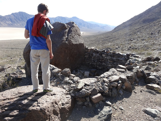
On the way back down the mountain, we discovered that
large rocks we had seen on the way up were actually used for walls for housing
for the miners.
Between the dust build up (from the gravel roads and the
dust storm in Texas and New Mexico) and the squashed insect guts (from Oklahoma
and Texas), the interiors were quite dirty. Ergo, when we got back to camp, I
finally wiped down all the interiors. Yay for cleanness again!
Our last morning in Death Valley we visited Ubehebe
Crater. This landmark created approximately 2000 years ago by magma steaming
underground water to the point that the hill blew its top. It would have been
filled with water long ago, except for the dry weather patterns here. Even the
countryside still has evidence of the silt it spew across the land, making it
look more like a picture in sepia than a real landscape.
There is a trail that follows the rim of the Crater,
which is about 1.5 miles total. With gusto, I thought we should go the whole
way. But after traipsing through the thick layer of pebbles to the Little Hebe
Crater, I thought that the walk around the entire crater would be a bit too
strenuous, thus we turned back.
That ended our escapades through Death Valley. After
filling up with water and picking up our trailer, we left the Valley to find
Internet and determine our next stop.
Throughout our travels on the paved roads of the Valley,
I was plagued by the question. The paved roads had no more than about 6 inches
of paved shoulder. Occasionally, however, the shoulder (on both sides) would
widen to about 2 feet for about 15 feet, then narrow again. Neither Jonathan
nor I had any clue why. As we were traveling back from the crater, I believe I
solved the puzzle, though; and I am quite pleased with myself. Although Death
Valley is dry, when rain storms do cross it, torrential floods and rivers
spring up and often cover the roads with wash. This can tear up the edges of
the road. I believe these shoulder expansions are sacrificial lambs at likely
wash locations, offering the shoulder to be torn up instead of the actual road.
This is just a deduction, though. If anyone knows for sure, you are welcome to
enlighten me.


No comments:
Post a Comment
Note: Only a member of this blog may post a comment.